| Find Louisiana State Museum on Facebook |
 | Find Louisiana State Museum on Twitter |
| 2016 Sunset Report |
| OLG & DCRT Strategic Plan 2020-21 through 2024-25 |

- Quality - Louisiana State Library
85% of the users of the State Library indicated that the State Library's services and resources was a good value for the State.Source: The Impact of the Louisiana Department of Culture, Recreation and Tourism on Louisiana's Economy and Quality of Life for Louisiana's Citizens - June 2006
- Louisiana's deep water ports
Did you know that Louisiana's five deep water ports handle more than 457 million tons of U.S. waterborne commerce a year? - Quality - Louisiana State Library
85% of the users of the State Library indicated that the State Library's services and resources was a good value for the State.Source: The Impact of the Louisiana Department of Culture, Recreation and Tourism on Louisiana's Economy and Quality of Life for Louisiana's Citizens - June 2006
- Atchafalaya Heritage Area
The Atchafalaya Heritage Area has been designated by Congress as a National Heritage Area.
- Impact - DCRT Returns Investment Dollars to Louisiana
For every state tax dollar spent by the Department of Culture, Recreation and Tourism, $5.86 is returned to the State Treasury and citizens of Louisiana.Source: The Impact of the Louisiana Department of Culture, Recreation and Tourism on Louisiana's Economy and Quality of Life for Louisiana's Citizens - June 2006
- Impact - Louisiana Office of Tourism Tops Returns on Investment
$13.90 is the return on investment for every dollar spent by the Office of Tourism. Over 175,000 people were directly employed by the Louisiana travel and tourism industry in 2004. In terms of production, $5.9 billion (3.8%) of Louisiana's Gross State Product was directly attributable to expenditures by visitors to LouisianaSource: The Impact of the Louisiana Department of Culture, Recreation and Tourism on Louisiana's Economy and Quality of Life for Louisiana's Citizens - June 2006
- Impact - Supporting the Louisiana Arts
Every dollar in state support for the Arts leverages $7 in earned and contributed revenue. Louisiana's cultural enterprises provide nearly 144,000 jobs for Louisiana citizens, accounting for 7.6% of total employment. Arts has a total economic impact of $934 million in Louisiana.Source: The Impact of the Louisiana Department of Culture, Recreation and Tourism on Louisiana's Economy and Quality of Life for Louisiana's Citizens - June 2006
- Impact - Visitors Generate State Revenue
In terms of tax revenues, visitor spending accounted for $677 million of 2004 Louisiana revenues, or 8.3% of the total 2004 State Budget.Source: The Impact of the Louisiana Department of Culture, Recreation and Tourism on Louisiana's Economy and Quality of Life for Louisiana's Citizens - June 2006
- Quality - Louisiana State Museums
95% of State Museum's visitors strongly agreed or agreed that the State Museum was an educational experience and has expanded their awareness of Louisiana's cultural history.Source: The Impact of the Louisiana Department of Culture, Recreation and Tourism on Louisiana's Economy and Quality of Life for Louisiana's Citizens - June 2006
- Quality - Historic Preservation and the Arts
78-80% of Louisiana residents believe that historic preservation and arts are important and should be high priorities.Source: The Impact of the Louisiana Department of Culture, Recreation and Tourism on Louisiana's Economy and Quality of Life for Louisiana's Citizens - June 2006
- Impact - Louisiana Serve Program
The Louisiana Serve Program in the Office of Lieutenant Governor returns 2.8 million in non-state revenue to Louisiana. - Impact - Louisiana State Museum
The Office of State Museum returns $6.99 for every tax dollar spent.Source: The Impact of the Louisiana Department of Culture, Recreation and Tourism on Louisiana's Economy and Quality of Life for Louisiana's Citizens - June 2006
- Impact - Louisiana State Parks
Visitor spending at Louisiana State Parks returns $3.23 in state taxes for every dollar spend on operating and maintaining all our beautiful parks. Out-of-state visitors to Louisiana State Parks spent almost $12 million in Louisiana and produced an economic impact of over $24 million. Louisiana residents spent another $29.2 million while visiting the parks.Source: The Impact of the Louisiana Department of Culture, Recreation and Tourism on Louisiana's Economy and Quality of Life for Louisiana's Citizens - June 2006
- Impact - Scenic Byways Program
The Scenic Byways program leverages $1.56 for every dollar spent by the program.Source: The Impact of the Louisiana Department of Culture, Recreation and Tourism on Louisiana's Economy and Quality of Life for Louisiana's Citizens - June 2006
- Louisiana State Parks and the National Register
Thirteen Louisiana State Parks sites are on the National Register of Historic Places. They include:
• Audubon State Historic Site
• Centenary State Historic Site
• Fort Pike State Historic Site
• Fort Jesup State Historic Site
• Longfellow-Evangeline State Historic Site
• Mansfield State Historic Site
• Marksville State Historic Site
• Plaquemine Lock State Historic Site
• Port Hudson State Historic Site
• Poverty Point State Historic Site
• Otis House at Fairview-Riverside State Park
• Rosedown Plantation State Historic Site
• Winter Quarters State Historic Site - Louisiana State Parks Visitation
Nearly two million people visited a Louisiana State Park last year. - Louisiana State Parks Grow and Renew
The Louisiana Office of State Parks has spent nearly $80 million in major construction projects since 2004, providing two brand-new parks and a new historic site, adding cabins and campsites to existing parks and building visitor center at one park, the preservation area and three historic sites. - Louisiana State Parks Wireless Internet
The Louisiana Office of State Parks provides free wireless internet access at all 20 recreational parks. Extensive coverage areas include most cabins, RV slips and campsites. - Louisiana State Parks Online Reservations
You can now make online reservations for cabins, campsites, lodges and group camps – at www.ReserveLaStateParks.com - Louisiana State Parks Honors National Parks Service Senior Pass Program
Visitors who hold an America the Beautiful Senior or Access Pass, and whose home State Park system honor the America the Beautiful passes for camping discounts, are entitled to a 50% reduction on camping fees at Louisiana State Parks. Certain restrictions apply, see State Parks' fees & facilities page for more information. - Louisiana State Parks Draw Media Attention
Louisiana State Parks sites have been featured in movie and television releases including "True Detective," CBS’ "Zoo," and "NCIS: New Orleans," "G.I. Joe: Retaliation," "Selfless," "Devil’s Due," and commercials for Popeyes and Toyota. - Capitol Park Welcome Center
The main meeting room in the Capitol Park Welcome Center is named after Margaret Taylor, wife of U.S. President Zachary Taylor. The couple resided in a small house near the present day location of Capitol Park until Taylor was elected to the Presidency.
Mapmaking, like art, was common to all prehistoric cultures. Because they did not have paper, Native Americans drew maps on the ground, in the snow, in the ashes of a campfire with a stick or twig, or on a scrap of animal skin or a piece of bone. Indigenous mapmakers also imparted geographical information to European cartographers. The Native American maps included in this exhibit, visual documents from an oral culture, offer glimpses of the ways they perceived and experienced North America before and immediately after the European encounter.
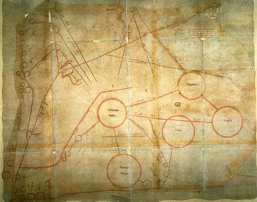 click for larger image | A Map Describing the Situation of the several Nations of Indians between South Carolina and the Massisipi Copyed from a Draught Drawn upon a Deer Skin by an Indian Cacique and Presented to Francis Nicholson Esqr. Governour of Carolina Unidentified Chickasaw mapmaker c. 1723 |
| This map depicts an area encompassing approximately 700,000 square miles from Texas to New York. Because several of the notations are from the western Muskogean language, it is believed that a Chickasaw drew this map and presented it to Nicholson on behalf of the Chickasaws. Several paths and river routes lead from the Chickasaw Nation, and several tribes allied with the French (F) surround the Chickasaws. It is likely the Chickasaws wished to illustrate their predicament to the English, their allies against the French. The original copy, drawn on deerskin-shaped paper, no longer exists. Courtesy British Public Record Office, Kew | |
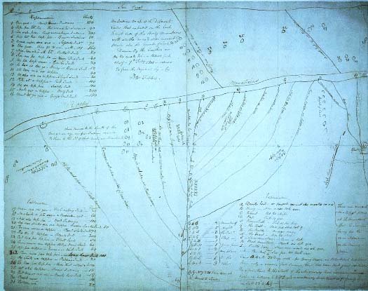 click for larger image | An Indian Map of the Different Tribes that Inhabit on the East & West Side of the Rocky Mountains with all the rivers & other remarkbl. places, also the number of Tents, etc. Ac ko mok ki (the Feathers), mapmaker Copied by Peter Fidler February 7, 1801 |
| Ac ko mok ki, a Blackfoot Indian chief, drew this map for Peter Fidler, postmaster and surveyor for the Hudson's Bay Company, 1788 1822. Because Ac ko mok ki probably sketched the original map on the ground or in the snow, Fidler carefully copied and annotated this information into his notebook, which is reproduced here. Oriented with west at the top, this map detailed for the first time the drainage network of the Missouri River and provided new information about the location and width of the Rocky Mountains (seen at the top of the map as a double-lined feature) and the Indian tribes living in the area. Ac ko mok ki surveyed and described to Fidler the adjacent plains for a distance of some 500 miles. His information depicted areas theretofore not explored by Europeans. Courtesy Hudson's Bay Company Archives, Provincial Archives of Manitoba This image may not be reproduced without the permission of the Hudson's Bay Company Archives | |
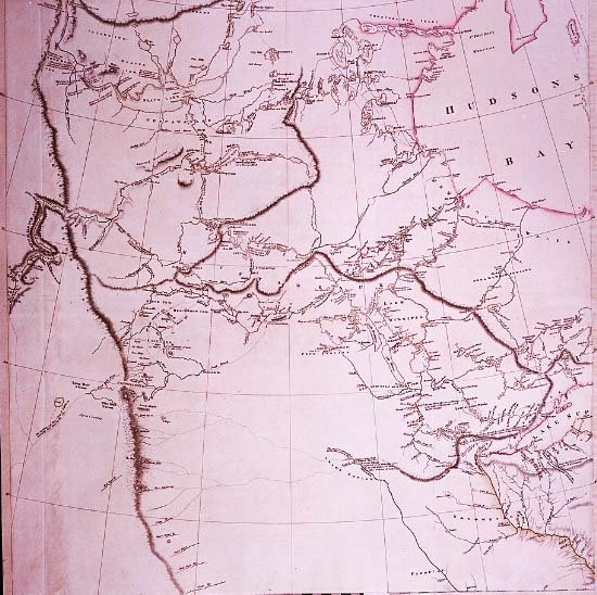 click for larger image | A Map Exhibiting all the Discoveries in the Interior Part of North America (Detail) Aaron N. Arrowsmith, mapmaker London, 1802 |
| Upon the transfer of the Louisiana territory to the United States, President Thomas Jefferson chose Captain Meriwether Lewis to head an expedition to explore the area between the Mississippi River and the Pacific Ocean. When Aaron Arrowsmith reissued a 1795 map of North America in 1802 he incorporated most of the details contained in Ac ko mok ki's map. Lewis and William Clark used this new edition to plan and execute their expedition. Courtesy Edward E. Ayer Collection, The Newberry Library, Chicago This image is not to be reproduced without the permission of the Newberry Library, Chicago | |
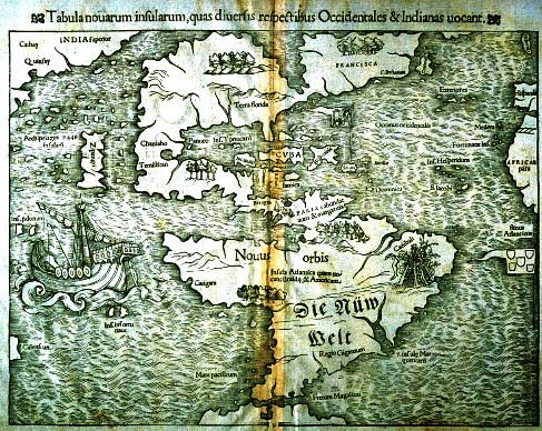 click for larger image | Tabula Novarum insularum, quas diversis respectibus Occidentales & Indianas vocant [Map of the New Islands Named by Various Sources the West and the Indies] From Cosmography Sebastian Münster, mapmaker Basle, 1550 |
| This woodcut map, first published in 1538, is the earliest known depiction of only North and South America as two land masses joined together and distinct from other continents. Versions of this map appeared in Latin, French, and other languages, but in the German edition shown here only the name Die Nüw Welt (the New World) has been translated. By implication North America is divided between France (Francisca) to the north and Spain (Terra Florida) to the south. Portugal's flag flies just off the African coast. Giovanni da Verrazano's accounts of the New World provided much of the cartographic detail included in this map, while the West Coast geography was taken from Marco Polo's description of Eastern Asia. Note that Japan, here named Zipangri, is placed just off the west coast of North America. Decorative elements adorning maps during the age of exploration reflected Old World assumptions regarding the nature of New World inhabitants. An engraver's ornamentation choice often determined the public's notion of other peoples. Cannibalistic South Americans are depicted here in the area of Brazil; just beneath this cartouche is an area labeled "Region of Giants" (Regio Gigantum). The large ship in the Pacific, usually identified as that of Magellan, bears little resemblance to late fifteenth-century sailing vessels. Magellan's Victoria probably had three masts but Münster depicted a single-masted type more typical of ships plying northern European waters during the fourteenth century. The northern coast of South America bears the legend abundae auro ac margaritis (abundant gold and pearls). Also note the isthmus of North Carolina, the result of Verrazano's miscomprehension of the Outer Banks of North Carolina. For many years after this map's publication early explorers looked for passage through the continent based on this faulty notion. Gift of the Friends of the Cabildo | |
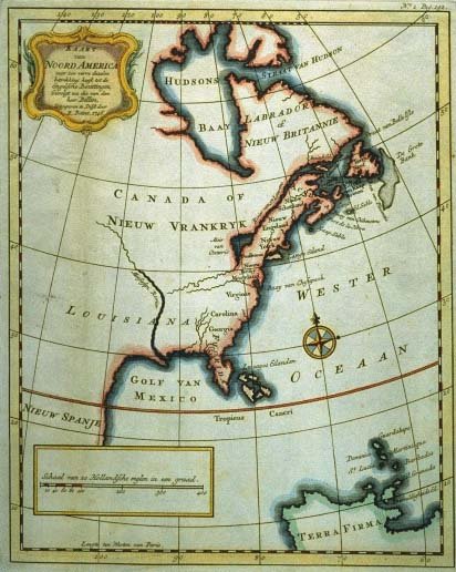 click for larger image | Kaart van Noord America voor zoo verre dezelve betrekking heeft tot de Engelsche Bezittingen [Map of North America Insofar as It Pertains to the English Possessions] From Noord America Attributed to Isaak Tirion R[einer] Boitet, publisher Delft, 1746 |
| This Dutch map is a fine example of the European penchant for cartographically claiming huge swaths of land on the North American continent. Territory east and south of Hudson Bay was claimed in the name of France (Vrankryk) and Britain (Britannie). Central America was labeled Nieuw Spanje (New Spain). Although many Western place-names along the eastern seaboard are identified, no Indian tribes are located, thereby discounting the existence of North America's indigenous populations and their claims to the land. Loaned by Dr. and Mrs. E. Ralph Lupin | |