| Find Louisiana State Museum on Facebook |
 | Find Louisiana State Museum on Twitter |
| 2016 Sunset Report |
| OLG & DCRT Strategic Plan 2020-21 through 2024-25 |

- Quality - Louisiana State Library
85% of the users of the State Library indicated that the State Library's services and resources was a good value for the State.Source: The Impact of the Louisiana Department of Culture, Recreation and Tourism on Louisiana's Economy and Quality of Life for Louisiana's Citizens - June 2006
- Louisiana's deep water ports
Did you know that Louisiana's five deep water ports handle more than 457 million tons of U.S. waterborne commerce a year? - Quality - Louisiana State Library
85% of the users of the State Library indicated that the State Library's services and resources was a good value for the State.Source: The Impact of the Louisiana Department of Culture, Recreation and Tourism on Louisiana's Economy and Quality of Life for Louisiana's Citizens - June 2006
- Atchafalaya Heritage Area
The Atchafalaya Heritage Area has been designated by Congress as a National Heritage Area.
- Impact - DCRT Returns Investment Dollars to Louisiana
For every state tax dollar spent by the Department of Culture, Recreation and Tourism, $5.86 is returned to the State Treasury and citizens of Louisiana.Source: The Impact of the Louisiana Department of Culture, Recreation and Tourism on Louisiana's Economy and Quality of Life for Louisiana's Citizens - June 2006
- Impact - Louisiana Office of Tourism Tops Returns on Investment
$13.90 is the return on investment for every dollar spent by the Office of Tourism. Over 175,000 people were directly employed by the Louisiana travel and tourism industry in 2004. In terms of production, $5.9 billion (3.8%) of Louisiana's Gross State Product was directly attributable to expenditures by visitors to LouisianaSource: The Impact of the Louisiana Department of Culture, Recreation and Tourism on Louisiana's Economy and Quality of Life for Louisiana's Citizens - June 2006
- Impact - Supporting the Louisiana Arts
Every dollar in state support for the Arts leverages $7 in earned and contributed revenue. Louisiana's cultural enterprises provide nearly 144,000 jobs for Louisiana citizens, accounting for 7.6% of total employment. Arts has a total economic impact of $934 million in Louisiana.Source: The Impact of the Louisiana Department of Culture, Recreation and Tourism on Louisiana's Economy and Quality of Life for Louisiana's Citizens - June 2006
- Impact - Visitors Generate State Revenue
In terms of tax revenues, visitor spending accounted for $677 million of 2004 Louisiana revenues, or 8.3% of the total 2004 State Budget.Source: The Impact of the Louisiana Department of Culture, Recreation and Tourism on Louisiana's Economy and Quality of Life for Louisiana's Citizens - June 2006
- Quality - Louisiana State Museums
95% of State Museum's visitors strongly agreed or agreed that the State Museum was an educational experience and has expanded their awareness of Louisiana's cultural history.Source: The Impact of the Louisiana Department of Culture, Recreation and Tourism on Louisiana's Economy and Quality of Life for Louisiana's Citizens - June 2006
- Quality - Historic Preservation and the Arts
78-80% of Louisiana residents believe that historic preservation and arts are important and should be high priorities.Source: The Impact of the Louisiana Department of Culture, Recreation and Tourism on Louisiana's Economy and Quality of Life for Louisiana's Citizens - June 2006
- Impact - Louisiana Serve Program
The Louisiana Serve Program in the Office of Lieutenant Governor returns 2.8 million in non-state revenue to Louisiana. - Impact - Louisiana State Museum
The Office of State Museum returns $6.99 for every tax dollar spent.Source: The Impact of the Louisiana Department of Culture, Recreation and Tourism on Louisiana's Economy and Quality of Life for Louisiana's Citizens - June 2006
- Impact - Louisiana State Parks
Visitor spending at Louisiana State Parks returns $3.23 in state taxes for every dollar spend on operating and maintaining all our beautiful parks. Out-of-state visitors to Louisiana State Parks spent almost $12 million in Louisiana and produced an economic impact of over $24 million. Louisiana residents spent another $29.2 million while visiting the parks.Source: The Impact of the Louisiana Department of Culture, Recreation and Tourism on Louisiana's Economy and Quality of Life for Louisiana's Citizens - June 2006
- Impact - Scenic Byways Program
The Scenic Byways program leverages $1.56 for every dollar spent by the program.Source: The Impact of the Louisiana Department of Culture, Recreation and Tourism on Louisiana's Economy and Quality of Life for Louisiana's Citizens - June 2006
- Louisiana State Parks and the National Register
Thirteen Louisiana State Parks sites are on the National Register of Historic Places. They include:
• Audubon State Historic Site
• Centenary State Historic Site
• Fort Pike State Historic Site
• Fort Jesup State Historic Site
• Longfellow-Evangeline State Historic Site
• Mansfield State Historic Site
• Marksville State Historic Site
• Plaquemine Lock State Historic Site
• Port Hudson State Historic Site
• Poverty Point State Historic Site
• Otis House at Fairview-Riverside State Park
• Rosedown Plantation State Historic Site
• Winter Quarters State Historic Site - Louisiana State Parks Visitation
Nearly two million people visited a Louisiana State Park last year. - Louisiana State Parks Grow and Renew
The Louisiana Office of State Parks has spent nearly $80 million in major construction projects since 2004, providing two brand-new parks and a new historic site, adding cabins and campsites to existing parks and building visitor center at one park, the preservation area and three historic sites. - Louisiana State Parks Wireless Internet
The Louisiana Office of State Parks provides free wireless internet access at all 20 recreational parks. Extensive coverage areas include most cabins, RV slips and campsites. - Louisiana State Parks Online Reservations
You can now make online reservations for cabins, campsites, lodges and group camps – at www.ReserveLaStateParks.com - Louisiana State Parks Honors National Parks Service Senior Pass Program
Visitors who hold an America the Beautiful Senior or Access Pass, and whose home State Park system honor the America the Beautiful passes for camping discounts, are entitled to a 50% reduction on camping fees at Louisiana State Parks. Certain restrictions apply, see State Parks' fees & facilities page for more information. - Louisiana State Parks Draw Media Attention
Louisiana State Parks sites have been featured in movie and television releases including "True Detective," CBS’ "Zoo," and "NCIS: New Orleans," "G.I. Joe: Retaliation," "Selfless," "Devil’s Due," and commercials for Popeyes and Toyota. - Capitol Park Welcome Center
The main meeting room in the Capitol Park Welcome Center is named after Margaret Taylor, wife of U.S. President Zachary Taylor. The couple resided in a small house near the present day location of Capitol Park until Taylor was elected to the Presidency.
In Western societies, maps evolved as part of a tradition that perceived land as a something one could buy, sell, control, and exploit. Thus, maps, like muskets and warships, became tools of European hegemony in the New World. Kings and wealthy landowners sponsored the creation of new maps, which were then often used for political reasons, such as claiming territory, or economic ones, such as financing expeditions or staking out trade routes.
A "war of maps" waged between England and France during the first half of the eighteenth century exemplifies how maps were used by competing European powers to claim territory in the New World. This cartographic confrontation culminated with the French and Indian War (known as the Seven Years' War in Europe), which in turn ended with the expulsion of France from the North American continent.
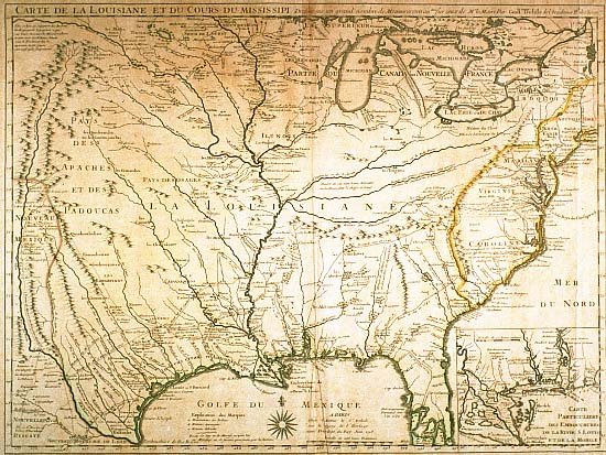 click for larger image | Carte de la Louisiane et du Cours du Mississipi Dressée sur un grand nombre de Memoires [Map of Louisiana and the Course of the Mississippi Drawn from a Large Number of Reports] Guillaume Delisle, mapmaker Paris, June 1718 |
| The first "shot" fired in the war of maps features North America from Long Island to the Rio Grande and southward to the Florida peninsula. Made by Delisle for the Company of the West, it had a distinct political purpose: to circumscribe and minimize Britain's western territories. Delisle characterized "Caroline" as discovered, named, settled, and possessed by France. This map also delineated French claims to the Rio Grande as the boundary line between Louisiana and Spanish Mexico. Gift of Helen and Solis Seiferth | |
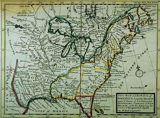 click for larger image | A New Map of ye North Parts of America claimed by France under ye Names of Louisiana, Mississipi, Canada & New France, with the Adjoyning Territories of England & Spain H[erman] Moll, mapmaker London, 1732 |
| This map was Britain's reply to Delisle's 1718 map. Because Britain had already established trading posts among the Indians in these regions, Moll extended the British borders of Carolina westward into territory along the Mississippi River already claimed by France. Gift of the Friends of the Cabildo | |
 click for larger image | Carte de la Louisiane et des Pays Voisins [Map of Louisiana and the Neighboring Regions] Jacques N. Bellin, cartographer Paris, 1755 |
| The next battle in the "war of the maps" came from Jacques Bellin. In this work, Bellin attempted to locate the Spanish, French, and British settlements along the eastern seaboard. All of the English colonies are closely contained east of the Appalachian mountains. This map is one of the better imitations of Delisle's 1718 map of Louisiana. However, Bellin did not include De Soto's route to the west, eliminated several outdated references, and added information derived from recent explorations. Gift of Samuel Wilson | |
 click for larger image | A Map of the British and French Settlements in North America . . . containing Part of New York, Pensilvania, New Jersey, Mary Land, Virginia, North & South Carolina, Georgia, Louisiana, and all the Countries Westward in the same Parallels so far as Discovered, shewing the Course of the Rivers Ohio, Missisipi &c. exhibiting the just Boundaries & the French Encroachments T[homas] Bowen, mapmaker London, 1755 |
| Bowen's response to Bellin was this map, which includes, in the upper left corner, a legend asserting that Virginia and New England extended "from the Atlantic ocean to the South sea." | |