| Find Louisiana State Museum on Facebook |
 | Find Louisiana State Museum on Twitter |
| 2016 Sunset Report |
| OLG & DCRT Strategic Plan 2020-21 through 2024-25 |

- Quality - Louisiana State Library
85% of the users of the State Library indicated that the State Library's services and resources was a good value for the State.Source: The Impact of the Louisiana Department of Culture, Recreation and Tourism on Louisiana's Economy and Quality of Life for Louisiana's Citizens - June 2006
- Louisiana's deep water ports
Did you know that Louisiana's five deep water ports handle more than 457 million tons of U.S. waterborne commerce a year? - Quality - Louisiana State Library
85% of the users of the State Library indicated that the State Library's services and resources was a good value for the State.Source: The Impact of the Louisiana Department of Culture, Recreation and Tourism on Louisiana's Economy and Quality of Life for Louisiana's Citizens - June 2006
- Atchafalaya Heritage Area
The Atchafalaya Heritage Area has been designated by Congress as a National Heritage Area.
- Impact - DCRT Returns Investment Dollars to Louisiana
For every state tax dollar spent by the Department of Culture, Recreation and Tourism, $5.86 is returned to the State Treasury and citizens of Louisiana.Source: The Impact of the Louisiana Department of Culture, Recreation and Tourism on Louisiana's Economy and Quality of Life for Louisiana's Citizens - June 2006
- Impact - Louisiana Office of Tourism Tops Returns on Investment
$13.90 is the return on investment for every dollar spent by the Office of Tourism. Over 175,000 people were directly employed by the Louisiana travel and tourism industry in 2004. In terms of production, $5.9 billion (3.8%) of Louisiana's Gross State Product was directly attributable to expenditures by visitors to LouisianaSource: The Impact of the Louisiana Department of Culture, Recreation and Tourism on Louisiana's Economy and Quality of Life for Louisiana's Citizens - June 2006
- Impact - Supporting the Louisiana Arts
Every dollar in state support for the Arts leverages $7 in earned and contributed revenue. Louisiana's cultural enterprises provide nearly 144,000 jobs for Louisiana citizens, accounting for 7.6% of total employment. Arts has a total economic impact of $934 million in Louisiana.Source: The Impact of the Louisiana Department of Culture, Recreation and Tourism on Louisiana's Economy and Quality of Life for Louisiana's Citizens - June 2006
- Impact - Visitors Generate State Revenue
In terms of tax revenues, visitor spending accounted for $677 million of 2004 Louisiana revenues, or 8.3% of the total 2004 State Budget.Source: The Impact of the Louisiana Department of Culture, Recreation and Tourism on Louisiana's Economy and Quality of Life for Louisiana's Citizens - June 2006
- Quality - Louisiana State Museums
95% of State Museum's visitors strongly agreed or agreed that the State Museum was an educational experience and has expanded their awareness of Louisiana's cultural history.Source: The Impact of the Louisiana Department of Culture, Recreation and Tourism on Louisiana's Economy and Quality of Life for Louisiana's Citizens - June 2006
- Quality - Historic Preservation and the Arts
78-80% of Louisiana residents believe that historic preservation and arts are important and should be high priorities.Source: The Impact of the Louisiana Department of Culture, Recreation and Tourism on Louisiana's Economy and Quality of Life for Louisiana's Citizens - June 2006
- Impact - Louisiana Serve Program
The Louisiana Serve Program in the Office of Lieutenant Governor returns 2.8 million in non-state revenue to Louisiana. - Impact - Louisiana State Museum
The Office of State Museum returns $6.99 for every tax dollar spent.Source: The Impact of the Louisiana Department of Culture, Recreation and Tourism on Louisiana's Economy and Quality of Life for Louisiana's Citizens - June 2006
- Impact - Louisiana State Parks
Visitor spending at Louisiana State Parks returns $3.23 in state taxes for every dollar spend on operating and maintaining all our beautiful parks. Out-of-state visitors to Louisiana State Parks spent almost $12 million in Louisiana and produced an economic impact of over $24 million. Louisiana residents spent another $29.2 million while visiting the parks.Source: The Impact of the Louisiana Department of Culture, Recreation and Tourism on Louisiana's Economy and Quality of Life for Louisiana's Citizens - June 2006
- Impact - Scenic Byways Program
The Scenic Byways program leverages $1.56 for every dollar spent by the program.Source: The Impact of the Louisiana Department of Culture, Recreation and Tourism on Louisiana's Economy and Quality of Life for Louisiana's Citizens - June 2006
- Louisiana State Parks and the National Register
Thirteen Louisiana State Parks sites are on the National Register of Historic Places. They include:
• Audubon State Historic Site
• Centenary State Historic Site
• Fort Pike State Historic Site
• Fort Jesup State Historic Site
• Longfellow-Evangeline State Historic Site
• Mansfield State Historic Site
• Marksville State Historic Site
• Plaquemine Lock State Historic Site
• Port Hudson State Historic Site
• Poverty Point State Historic Site
• Otis House at Fairview-Riverside State Park
• Rosedown Plantation State Historic Site
• Winter Quarters State Historic Site - Louisiana State Parks Visitation
Nearly two million people visited a Louisiana State Park last year. - Louisiana State Parks Grow and Renew
The Louisiana Office of State Parks has spent nearly $80 million in major construction projects since 2004, providing two brand-new parks and a new historic site, adding cabins and campsites to existing parks and building visitor center at one park, the preservation area and three historic sites. - Louisiana State Parks Wireless Internet
The Louisiana Office of State Parks provides free wireless internet access at all 20 recreational parks. Extensive coverage areas include most cabins, RV slips and campsites. - Louisiana State Parks Online Reservations
You can now make online reservations for cabins, campsites, lodges and group camps – at www.ReserveLaStateParks.com - Louisiana State Parks Honors National Parks Service Senior Pass Program
Visitors who hold an America the Beautiful Senior or Access Pass, and whose home State Park system honor the America the Beautiful passes for camping discounts, are entitled to a 50% reduction on camping fees at Louisiana State Parks. Certain restrictions apply, see State Parks' fees & facilities page for more information. - Louisiana State Parks Draw Media Attention
Louisiana State Parks sites have been featured in movie and television releases including "True Detective," CBS’ "Zoo," and "NCIS: New Orleans," "G.I. Joe: Retaliation," "Selfless," "Devil’s Due," and commercials for Popeyes and Toyota. - Capitol Park Welcome Center
The main meeting room in the Capitol Park Welcome Center is named after Margaret Taylor, wife of U.S. President Zachary Taylor. The couple resided in a small house near the present day location of Capitol Park until Taylor was elected to the Presidency.
Throughout history certain maps appeared which, because of accurate details and incorporation of the results of new explorations, cartographers call "foundation," or "mother," maps. Their influence persisted long after later discoveries and settlements because until the nineteenth century, most mapmakers reproduced their predecessor's work. True geographers were few and far between, and most mapmakers were simply draftsmen, engravers, or map publishers wishing to issue "new" maps. "Changes" often consisted of scratching off the date of publication from an earlier copperplate and replacing it with a more recent date. Sometimes the publisher did not even bother to alter the plate. He merely erased the date on unsold maps, inserted a more recent date, and advertised the map as a new edition. Sometimes "new" maps were created by incorporating, more or less haphazardly, various place-names, rivers, and other geographical features of previously printed maps.
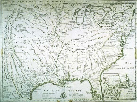 click for larger image | Carte de la Louisiane et du Cours du Mississipi Dressée sur un grand nombre de Memoires entrautres sur ceux de Mr. le Maire [Map of Louisiana and the Course of the Mississippi, Drawn from a Large Number of Reports, and among others on those of Mr. le Maire] Guillaume Delisle, mapmaker Paris, June 1718 |
| This map was one of the most important and influential early eighteenth-century foundation maps of the Mississippi Valley. It is the first detailed map of the Gulf region and the Mississippi, the first printed map to show Texas as a name (Mission de los Teijas), and the first to show some of the land routes of earlier centuries. Quickly copied by French, Dutch, German, Italian, and English mapmakers, it was the chief authority for the Mississippi River for over fifty years. Although New Orleans was founded in 1718, the year this map was published, it was not shown on the first edition. A striking characteristic of the map is the nearly correct delineation of the Mississippi River, which differs little from that of present-day maps. The Appalachian, Ozark, and Rocky Mountains are properly located. The map includes several references to such mineral resources as salt, copper, lead, and iron and clearly locates many Indian tribes. Some are represented as errantes (wandering) and Antropophagi (cannibals), references to the Attakapa Indians. This was the first modern map to trace the route of Hernando de Soto; it also traces the routes of Alonso de Leon in 1689, Louis Jouchereau St. Denis in 1713 1716, and other explorers. The Mr. le Maire to whom Delisle expresses his special indebtedness for information used in this map, was François le Maire, a French missionary at Mobile who had an interest in geography and the skill required to draw accurate maps. Le Maire sent information to the priests of his order in Paris. Among these was Father Bobé, a friend of the Delisles, who gave to Delisle le Maire's memoirs and maps, which included the many new features in North America. Loaned by Gaspar Cusachs | |
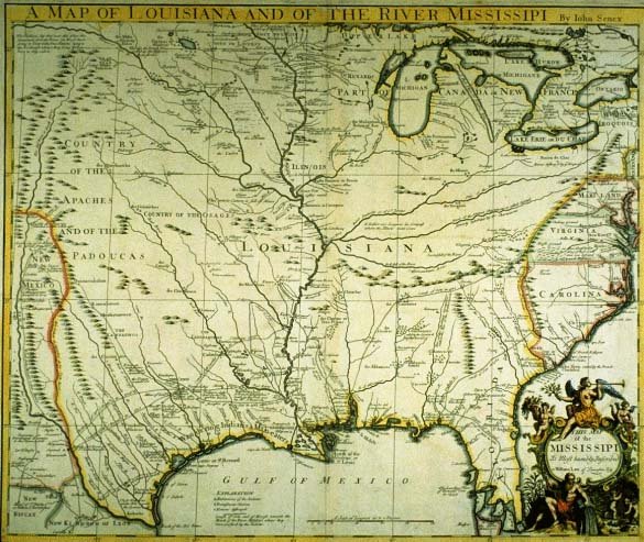 click for larger image | A Map of Louisiana and of the River Mississipi John Senex, mapmaker London, 1721 |
| The British imitation of Delisle's 1718 map, described as "a most impudent plagiarism" by one reviewer, does not include Delisle's reference to the French priority of settlement and does not represent as large an area as does Delisle's map. The decorative elements of this map portray Europe's belief that fabulous riches awaited those who came to the New World. The left side represents the New World's agricultural wealth while the right symbolizes mineral wealth. Sitting atop the elaborately engraved title cartouche is a winged female figure personifying Fame. She holds a laurel branch in one hand, a trumpet in the other. A cherub holds an upright cornucopia filled with agricultural bounties, and sugarcane grows below. Another cherub pours coins from an overturned cornucopia toward two cherubim busily working in a mine presumably a gold or silver mine. The male figure holding an overturned urn with water pouring forth personifies the Mississippi River. Gift of Samuel Wilson | |
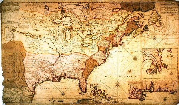 click for larger image | Carte de la Nouvelle France ou se voit le cours des Grandes Rivieres de S. Laurens & de Mississipi [Map of New France Showing the Course of the Great Rivers St. Lawrence and Mississippi] Gerard van Keulen, mapmaker Amsterdam, 1718 |
| Relying heavily on Delisle's 1718 map, van Kuelen omitted New Orleans (or did not yet have that information), did not include De Soto's route, and added the location of many Indian tribes. The Dutch mapmaker delineated all of New England and much of Canada and depicted Florida as a complete peninsula unlike Delisle, who identified the area as an archipelago, a common error of early European cartographers. This map includes the legend, seen to the west of the Mississippi River, "land filled with herds of wild buffalo (pays remoli de troupeaux de Bouefs Sauvages)." Loaned by Dr. and Mrs. E. Ralph Lupin | |
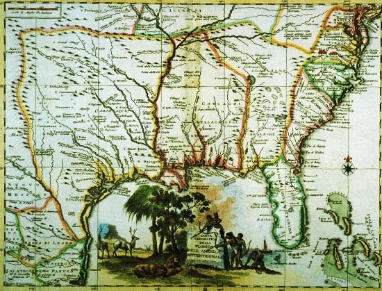 click for larger image | Carta Geografica Della Florida Nell'America Settentrionale [Geographical Map of Florida in North America] Unidentified mapmaker c. 1740 |
| While partly relying on Delisle's 1718 map, this unidentified Italian mapmaker omitted much detail, including the founding of New Orleans. One of the remarkable features of this map is the title cartouche depicting Native Americans hunting sleeping lions. European engravers and mapmakers commonly confused attributes of the Americas with those of Africa, and they often interchanged the flora and fauna of the three continents. It is also possible that the engraver was attempting to illustrate the American cougar, described by early explorers as a lion. Gift of the Friends of the Cabildo | |